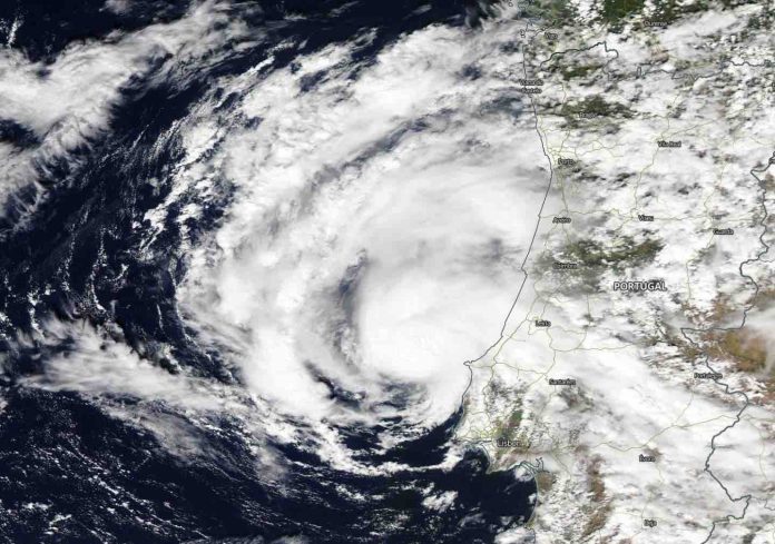
Subtropical Storm Alpha has formed near the coast of Portugal, becoming the first named storm using the Greek Alphabet list, now that the annual list of names is exhausted. NASA’s Aqua satellite obtained visible imagery of the new storm.
NASA Satellite View
The Moderate Resolution Imaging Spectroradiometer or MODIS instrument that flies aboard NASA’s Aqua satellite captured a visible image of Subtropical Storm Alpha on Sept. 18 at 8:30 a.m. EDT (1:30 p.m. local time) near Portugal. The image showed a better-organized small low-pressure area that has been rotating around a larger extratropical low pressure area. Satellite imagery shows that moderate-to-deep convection has persisted near the center creating thunderstorms since last night. Meanwhile scatterometer data shows a closed 40-knot low-pressure area, and the National Hurricane Center noted that radar images from Portugal show a definite organized convective pattern.
Although Alpha is “likely neutral- or cold-core, it has developed enough tropical characteristics to be considered a subtropical storm,” said Eric Blake, senior hurricane specialist at NOAA’s National Hurricane Center (NHC) in Miami, Fla.
Satellite imagery was created using NASA’s Worldview product at NASA’s Goddard Space Flight Center in Greenbelt, Md.
Alpha’s Status
At 12:30 p.m. EDT (1630 UTC), NOAA’s National Hurricane Center (NHC) noted the center of Subtropical Storm Alpha was located near latitude 39.9 degrees north and longitude 9.3 degrees west. That is just 75 miles (125 km) north of Lisbon, Portugal. The storm is moving toward the northeast near 17 mph (28 kph), and this general motion is expected during the next day or so before dissipation. Maximum sustained winds are near 50 mph (85 kph) with higher gusts. The estimated minimum central pressure is 999 millibars.
Alpha’s Impacts
Alpha should move across the coast of west-central Portugal during the next couple of days. Little change in strength is expected before landfall, with rapid weakening over land through the weekend.
NHC said Alpha is expected to produce 1 to 2 inches (25 to 50 mm) of rainfall, with isolated amounts of 3 inches (75 mm) over the northern portion of Portugal and into west-central Spain through Saturday morning.
Information on wind hazards from Alpha can be found in products from the Portuguese Institute for Sea and Atmosphere at http://www.ipma.pt.
Global models show the small low pressure area moving northeastward for the next 24 hours before dissipating over northern Spain or the Bay of Biscay.


